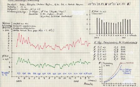
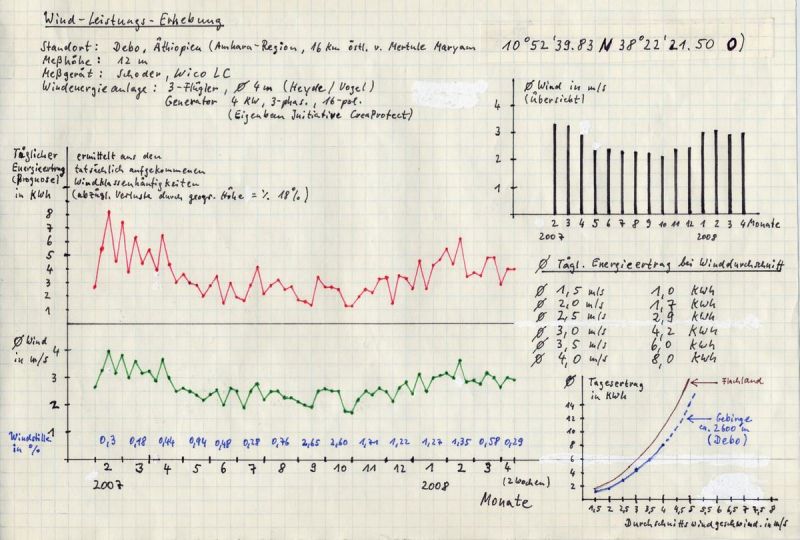
After regular data of wind conditions were collected between February 2007 and April 2008 from our wind powered turbine, (12 m high) by means of the technicians data loggers, (and is continuously being collected since October 2008), We can now discuss with more concrete evidence about wind conditions at this location Debo. Until now, we were only dependent on short time measurements and impressions given from the population. GTZ Wind maps for Ethiopia are available, however for many regions these are more an estimation since there is a lack of measuring points.
See the implementations of Mr. B. Jargstorf, GTZ, sides 19-24
It becomes clear in these explanations that the requirements for wind energy are very different in Ethiopia. The regions along the mountain range of the northern Mekelle until after Addis Abeba, the mountain regions of the north-eastern Harar along the valley into the south, also east of Addis Abeba (Nazareth), then north of the Tina-Sees and the entire East region of the country in the direction of Somalia are distinctly windier. Strangely enough, the highlands of Ethiopia are rather wind-poor. Our measurements in Debo also confirm this, although the values in general in Debo are better than those of the highlands. Our measuring point (machine head wind turbine) is not ideal because of the wind current at the edge of a valley, that yields up currents up the valley slopes instead of crosswinds, (from N-NE). The winds are better coming from the field (v. S). Unfortunately we could not realize the comparative measurements 1 km from Debo (college; backfield character), because of a defect in the second measuring instrument. However, we had the impression that this back field situation was wind-technically speaking, clearly better than the valley slope situation.
In the end the question is how much energy can be reaped from these wind speeds on average each day. From 2007 until 2009, we ran the canvas wind turbine, that admittedly brought very fast high performances from wind speeds of 5 m/hr, but the mechanism started slowly and could not use the wind ratings under 5 m/hr. Since we could only complete the new gearless installation, (see. "Technical description “and "result report 2009 “) in October 2009, On the basis of detailed measurements taken in Rüsseina we have been able to determine a prognosis report for energy profit of Debo. We have proceeded rather conservatively in the profit calculation on this occasion. From all profit data ascertained from Rüsseina, we corrected the results with a 20 percent decrease, since the air presure and with that the energy density at 2600 m a.s.l. in Debo is lower compared to Rüsseina at approximately 250 m above sea level.
The result
The wind speeds in Debo are on average too low with 2,5 m/hrs for the running of a wind powered turbine alone. The daily energy profit with our wind powered installation (rotor diameters 4 m) is with these winds barely 3 kHz. In this case, the solar installation evens out this short coming. In order to meet the daily energy demand of Debo through wind strength alone,( 5 kHz for light and small appliances), we needed wind velocity, that measured in 12 m of height between 3,5 and 4 m/hr at least, (in the mountains 6-8 kHz per day in the lowlands 8 - 13 kHz.) this actually is a not at all such a tall order, if one considers many areas in Ethiopia and Africa in general, where much higher wind values are present. So seen, our wind strength installation could, as a virtually maintenance-free "low wind artist “for island installation in Africa, have a promising future. Astonishing: The measurements of windlessness lies extraordinarily low (usually under 2%), which means a bonus for the reliability of wind powered installations.
Measurements
-
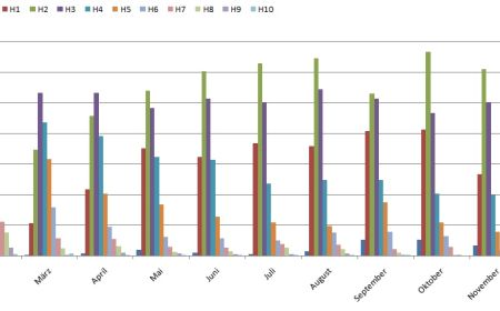
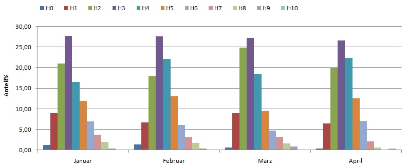
Windklassen Debo 2007 -
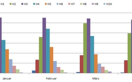
Windklassen Debo 2008 -
Windverhältnisse
The wind conditions in Tula
(Compare concrete information under the category "the project in Tula")
While the wind conditions are rather poor in the highland of Ethiopia, contrary to first assumptions, the wind in individual regions clearly blows more strongly. Wind measurements in Tula on the periphery elevation of the Great Rift Valley (in close proximity to the city Hossaina) show following results:
-
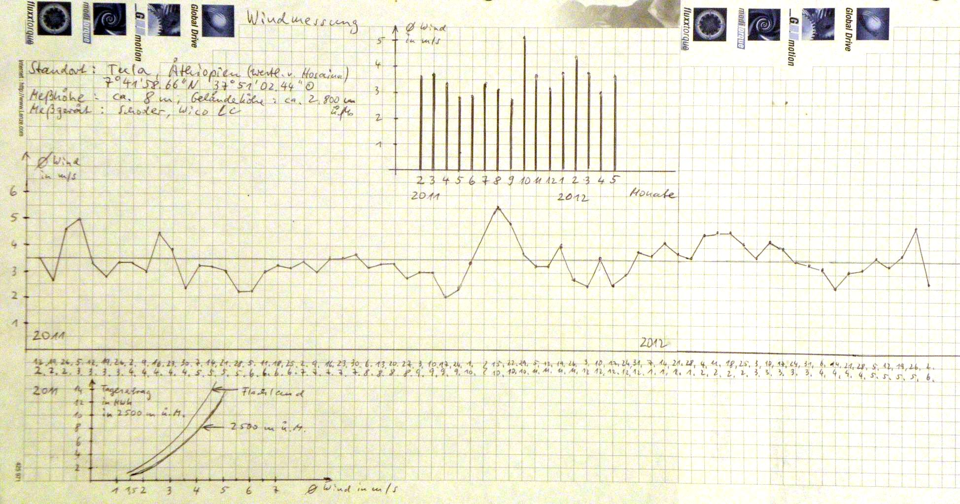
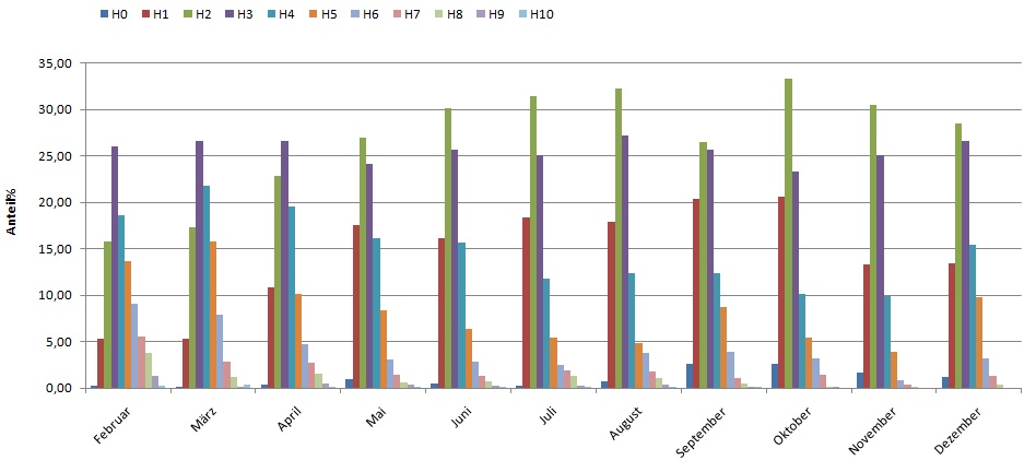
Wind power survey in Tula